The Global Spatial Inequality Index (GSII)
A global framework to measure how cities distribute opportunity, infrastructure, and risk
Global Baseline 2026 — 100 Cities
GSII is AZHJ’s flagship global initiative to measure spatial inequality within cities.
The Core Idea
Inequality is not only about income or averages—it is about where people live, what they can reach, and the conditions they are exposed to.
Across cities, access to jobs, services, infrastructure, and environmental safety varies dramatically between neighbourhoods. These spatial differences shape life chances, economic mobility, and long-term resilience.
Yet most global measures remain blind to how inequality is structured across space.
The GSII addresses this gap.
Inequality is Spatial
Why Existing Measures are not Enough?
What Current Indices Miss
Traditional indices have transformed how inequality is measured—but they do not capture how it is experienced spatially.❋ Income inequality measures distribution, not location❋ Development indicators rely on national averages❋ Sectoral indices isolate dimensions without spatial contextA city may perform well globally while remaining deeply unequal locally.
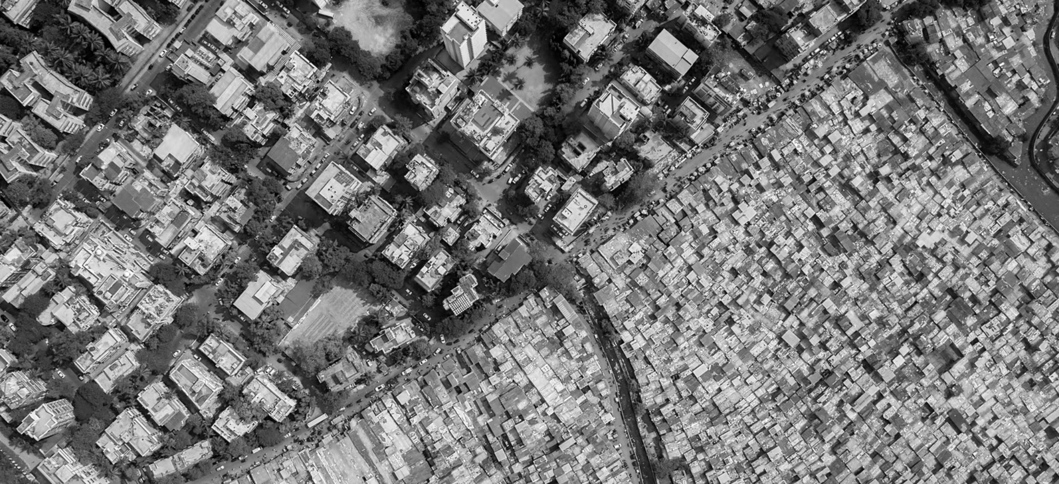
What is Spatial Inequality?
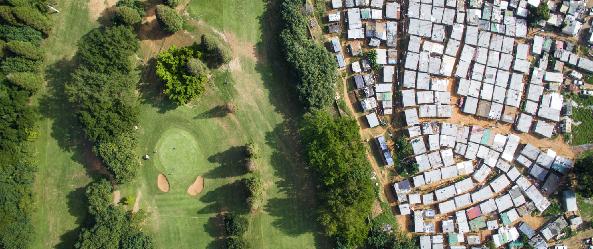
A City Scale Reality
Spatial Inequality Refers to the Uneven Distribution of:
❋ Access to Economic Opportunities❋ Infrastructure and Services❋ Urban Connectivity❋ Environmental Conditions It is Embeded In:
❋ Infrastructure Reliability❋ Housing Conditions❋ Commuting Times❋ Exposure to Heat, Pollution, & RiskSpatial Inequality is Built into the Structure of Cities.
The GSII Approach
A Multidimensional Framework
The GSII introduces a city-scale, multidimensional approach to measuring spatial inequality.

It is designed to:
❋ Assess inequality within cities, not only between them❋ Integrate multiple dimensions of urban life❋ Enable global comparability❋ Support evidence-based decision-makingRather than relying on a single metric, the GSII captures how different urban systems shape access, inclusion, and exposure across neighbourhoods.
What We Are Building
Global Baseline – Phase I
AZHJ is developing the first Global Urban Spatial Inequality Baseline, covering approximately 100 cities worldwide.

This baseline will establish a comparable framework for measuring spatial inequality across urban systems, identify global typologies, and provide the foundation for future benchmarking and city-level diagnostics.
This initial phase will:
❋ Establish a comparable measurement framework❋ Generate city-level spatial inequality profiles❋ Identify global patterns and typologies❋ Provide a foundation for future benchmarkingGlobal Baseline 2026
Why It Matters?
From Measurement to Action
Understanding spatial inequality is essential for:❋ Urban planning and land-use decisions❋ Infrastructure investment prioritisation❋ Improving access to jobs and services❋ Climate adaptation and risk reduction❋ Advancing inclusive urban developmentWithout measuring spatial inequality, policy interventions risk reinforcing existing disparities.
How GSII Works?
Our Methodolgy
The GSII evaluates cities across multiple dimensions of spatial inequality, capturing how urban systems distribute:❋ Access to opportunities❋ Infrastructure and services❋ Connectivity and mobility❋ Environmental exposureWho It Is For?

National & Local Governments
International Development Agencies
Urban Planners & Policy Makers
Research InstitutionsHow Cities Can Engage
Work with AZHJ
Cities and institutions can engage with GSII to:❋ Assess spatial inequality within their urban systems❋ Benchmark against global peers❋ Inform policy and investment decisionsAZHJ offers tailored city-level evaluations that integrate higher-resolution data and policy analysis.
The GSII measures spatial inequality to provide the evidence base required to advance spatial justice in cities worldwide.